Storm Boelo from the lens of GNSS water vapor
Storm Boelo crossed the UK on Saturday 24 October. As it came in, Skyfora measured the water vapor above GNSS receivers in real time. At two receivers in England with an Environment Agency rain gauge nearby, we compared the vapor with the rain that fell.
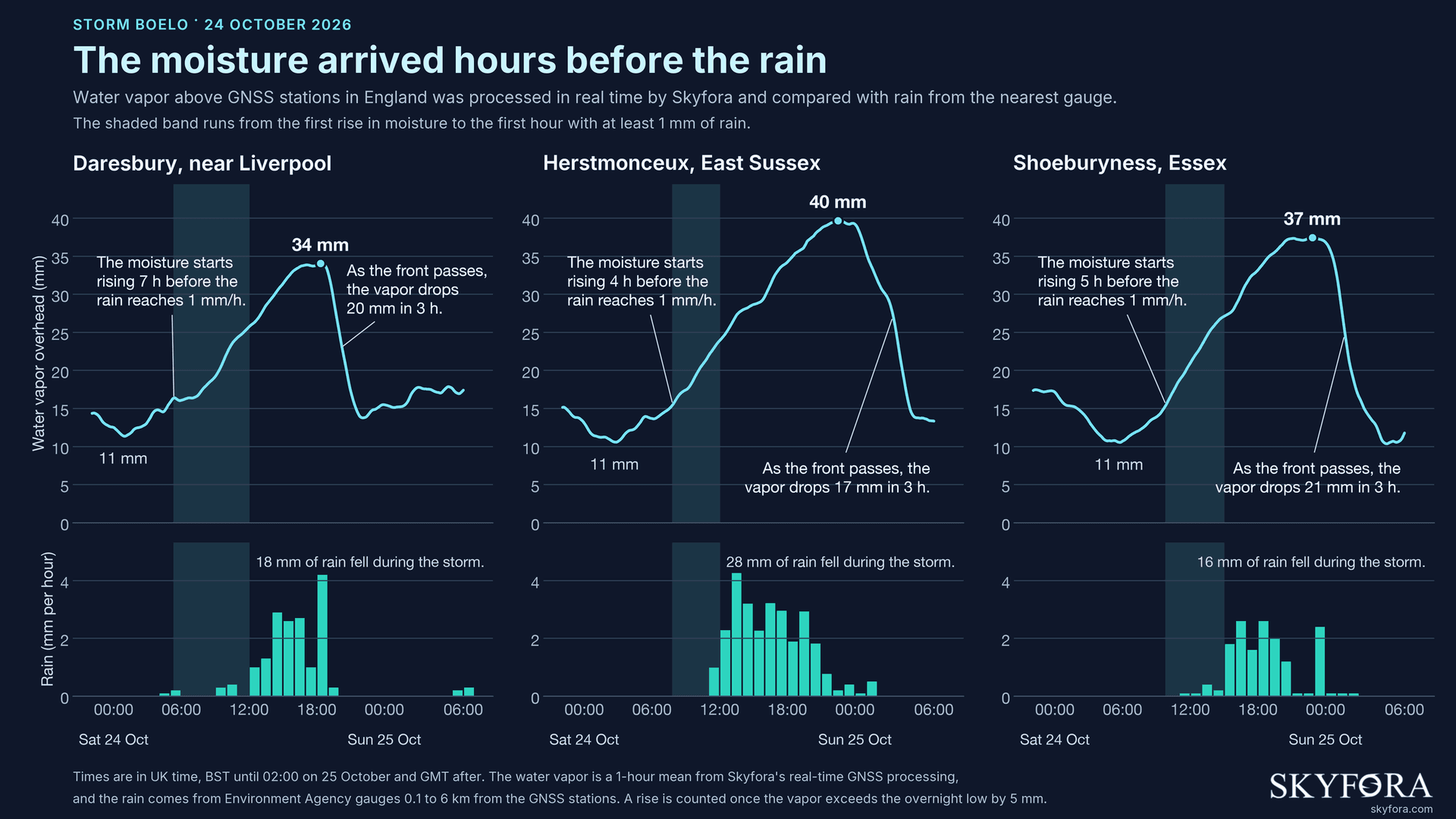
Illustration. Shaded - from the first rise in moisture to the first hour with at least 1mm of rain. Water vapour - Skyfora realtime GNSS processing, 1-hour mean. Rain - nearest Environment Agency gauges, 0,1-6km from the GNSS stations. Rise = 5 mm above the overnight low. UK time:BST until 02:00 on 25 Oct, GMT after.
Boelo, we see you
Near Liverpool, the water vapor started to climb at 5:20 am, almost 7 hours before the rain set in. In East Sussex the rise came later in the morning, and there too it came hours before the rain. By the evening, the vapor had grown from about 11 mm overnight to between 34 and 40 mm, 3 to 4 times as much. When the cold front passed, it fell by 17 to 21 mm in 3 hours.
GNSS benefits over weather radar
Weather radar sees rain only once it has formed, while GNSS sees the moisture building up before that. Radar extrapolation, a common way to forecast the next few hours, moves existing rain forward along its track, so it has nothing to work with where rain has not started yet. Water vapor alone does not make rain, so the real test is whether a forecast can use it.
We tested this with our AI nowcaster over New York State. Where radar extrapolation forecast no rain, adding GNSS water vapor made the model 18% better at telling where rain would appear 3 hours ahead. The gain grows from 4% at 15 minutes, and most of it comes from fewer false alarms.
GNSS, 2-3 hours proxy for precipitation and weather changes
GNSS helps most 2 to 3 hours ahead, where forecasts built on radar alone are weakest. Today the standard measurements come from public reference stations that sit tens or hundreds of kilometers apart. GNSS receivers in telecom networks can fill the space between them.